
Hi there, Dear Reader. It’s late morning here in New Hometown, Florida on Saturday, July 3, 2021. The current temperature is 79˚F (27˚C) under light rain . With the wind blowing from the west at 8 MPH (13 KM/H) and humidity at 76%, the heat index is 79˚F (27˚C). Today’s forecast calls for scattered rain showers and a high of 86˚F (30˚C). Tonight, scattered showers will continue. The low will be 75˚F (24˚C). Today’s Air Quality Index (AQI) is 37 or Good.
I have been up and about for several hours. I almost woke up at 5 AM when I had to get up to “use the facilities,” but even though it took me a while, I managed to doze off for another 90 or so minutes before getting up for good between 6:45 and 7 AM. I usually don’t sleep past 6:30 AM; my body clock is simply not “set” so that I can sleep in until 9 or 10 AM. But because the day is so dark and dreary – and because I still have a cold – I have not done much besides putter about on Facebook and keep a wary eye on Tropical Storm Elsa updates.
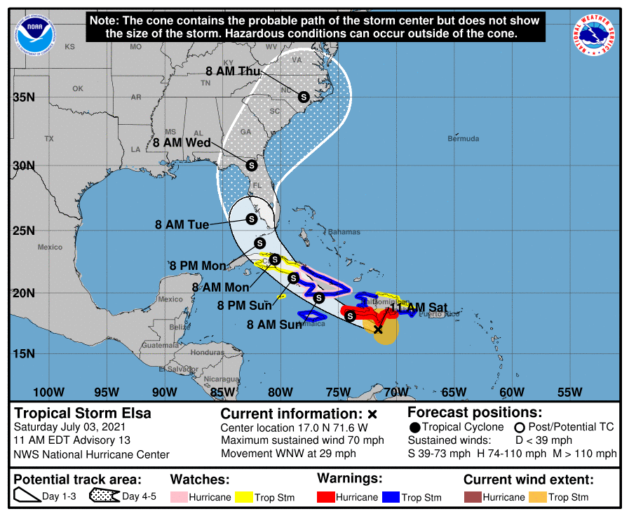
And speaking of the devil, here is the latest public update from the National Hurricane Center in Miami:
BULLETIN
Tropical Storm Elsa Intermediate Advisory Number 12A
NWS National Hurricane Center Miami FL AL052021
800 AM AST Sat Jul 03 2021
…ELSA MOVING RAPIDLY TOWARD THE SOUTH COAST OF HISPANIOLA…
…CONDITIONS EXPECTED TO DETERIORATE THERE OVER THE NEXT SEVERAL
HOURS…
SUMMARY OF 800 AM AST…1200 UTC…INFORMATION
———————————————-
LOCATION…16.5N 70.3W
ABOUT 110 MI…175 KM SE OF ISLA BEATA DOMINICAN REPUBLIC
ABOUT 440 MI…710 KM ESE OF KINGSTON JAMAICA
MAXIMUM SUSTAINED WINDS…75 MPH…120 KM/H
PRESENT MOVEMENT…WNW OR 290 DEGREES AT 31 MPH…50 KM/H
MINIMUM CENTRAL PRESSURE…999 MB…29.50 INCHES
WATCHES AND WARNINGS
——————–
CHANGES WITH THIS ADVISORY:
None.
SUMMARY OF WATCHES AND WARNINGS IN EFFECT:
A Hurricane Warning is in effect for…
* Southern coast of Dominican Republic from Punta Palenque to the
border with Haiti
* Southern portion of Haiti from Port Au Prince to the southern
border with the Dominican Republic
* Jamaica

A Tropical Storm Warning is in effect for…
* The coast of Haiti north of Port Au Prince
* South coast of the Dominican Republic east of Punta Palenque to
Cabo Engano
A Hurricane Watch is in effect for…
* The Cuban provinces of Camaguey, Granma, Guantanamo, Holguin,
Las Tunas, and Santiago de Cuba
A Tropical Storm Watch is in effect for…
* North coast of the Dominican Republic from Cabo Engano to
Bahia de Manzanillo
* Cayman Brac and Little Cayman
A Hurricane Warning means that hurricane conditions are expected
somewhere within the warning area. Preparations to protect life
and property should be rushed to completion.
A Tropical Storm Warning means that tropical storm conditions are
expected somewhere within the warning area.
A Hurricane Watch means that hurricane conditions are possible
within the watch area. A watch is typically issued 48 hours
before the anticipated first occurrence of tropical-storm-force
winds, conditions that make outside preparations difficult or
dangerous.
A Tropical Storm Watch means that tropical storm conditions are
possible within the watch area.
Interests elsewhere in the Virgin Islands, Puerto Rico, Cuba, the
Cayman Islands, the Florida peninsula, and the Florida Keys should
monitor the progress of Elsa. Additional watches and warnings
will likely be required later today.
For storm information specific to your area, please monitor
products issued by your national meteorological service.
DISCUSSION AND OUTLOOK
———————-
At 800 AM AST (1200 UTC), the center of Tropical Storm Elsawas located
near latitude 16.5 North, longitude 70.3 West. Elsa is moving very
quickly toward the west-northwest near 31 mph (50 km/h). A decrease
in forward speed is expected later today and Sunday, followed by a
turn toward the northwest Sunday night or Monday. On the forecast
track, Elsa will move near the southern coast of Hispaniola later
today and tonight, and move near Jamaica and portions of eastern
Cuba on Sunday. By Monday, Elsa is expected to move across central
and western Cuba and head toward the Florida Straits.
Maximum sustained winds are near 75 mph (120 km/h) with higher
gusts. Little change in strength is expected today, but slow
weakening is forecast on Sunday and Monday when Elsa is expected to
be near or over Cuba.
Hurricane-force winds extend outward up to 25 miles (35 km) from
the center and tropical-storm-force winds extend outward up to 125
miles (205 km).
The minimum central pressure estimated from Air Force Reserve
Hurricane Hunter aircraft data is 999 mb (29.50 inches).
HAZARDS AFFECTING LAND
———————-
Key messages for Elsa can be found in the Tropical Cyclone
Discussion under AWIPS header MIATCDAT5, WMO header WTNT45 KNHC and
on the web at
http://www.hurricanes.gov/graphics_at5.shtml?key_messages.
WIND: Hurricane conditions are expected in the hurricane warning
area in Haiti and the Dominican Republic later today. Hurricane
conditions are expected on Jamaica tonight or Sunday, and are
possible in eastern Cuba on Sunday.
STORM SURGE: A storm surge will raise water levels above normal tide
levels by as much as the following amounts in areas of onshore flow
within the hurricane watch and warning areas…
Southern coast of Cuba…3 to 5 feet
Southern coast of Hispaniola…2 to 4 feet
Jamaica…1 to 3 feet
RAINFALL: The outer rain bands associated with Elsa will impact
Puerto Rico today with rainfall totals of 1 to 3 inches with
localized amounts of 5 inches possible. This rain may lead to
isolated flash flooding, minor river flooding, and mudslides.
Across portions of southern Hispaniola and Jamaica, rainfall of 4 to
8 inches with isolated maximum amounts of 15 inches is expected
Saturday into Sunday. This rain may lead to scattered flash
flooding and mudslides.
Across portions of the Cayman Islands and Cuba Sunday into Monday,
rainfall of 5 to 10 inches with isolated maximum amounts of 15
inches is expected. This will result in significant flash flooding
with mudslides in Cuba.
Rainfall from Elsa is likely to impact portions of the Florida Keys
and southern Florida early next week. Amounts of 2 to 4 inches with
localized maximum amounts up to 6 inches will be possible, which may
result in isolated flash, urban, and minor river flooding.
SURF: Swells generated by Elsa will spread westward across the
Caribbean Sea through the weekend. These swells are likely to cause
life-threatening surf and rip current conditions. Please consult
products from your local weather office.
Judging from the information in this advisory, it looks like most of Florida is going to feel the effects of Elsa over the next few days. My old neighborhood in Miami-Dade will probably experience really bad weather as early as Monday or Tuesday, but we’ll get some of Elsa’s wind and rain here in New Hometown later on, too. Hopefully the storm won’t intensify after making its way through the Greater Antilles, but even tropical storms can cause power outages and flooding.
Ugh. I hate hurricane season.

I don’t think I’ll be online much during the day. The forecast for today is, as noted above, not exactly one that lends itself for any kind of outdoor activities, and even though my Weather app says it’s “just” Light Rain, it is alarmingly dark. and I’ve already heard two BOOMs of muffled but distinct thunder.
In any case, even though I took my first dose of DayQul, I have a sinus headache and a stuffy nose, so I am in no condition to sit at my desk all day, even if it is just to game, lurk on Facebook, or watch YouTube videos.
Summer colds are, as you probably know, the worst.
I’ll probably end up reading a book or listening to music on my tablet. It’s nice to have options for entertainment on a rainy day.
Well, that about wraps it up for this installment of A Certain Point of View, Too, so I’ll just close for now. Until next time, Dear Reader, stay safe, stay healthy, and I’ll catch you on the sunny side of things.


Comments
2 responses to “Musings & Thoughts for Saturday, July 3, 2021, or: Tracking Elsa on a Dark, Rainy Florida Weekend”
I’m happy it’s curving a little more east for selfish reasons. I’ve dealt too many times with people who want to cancel reservations because the weather is bad.
LikeLike
Personally, I would have been happier if it had dissipated or turned more toward Texas. For selfish reasons, since my area will be affected more directly.
LikeLiked by 1 person