
Hi, there, Dear Reader. It’s late morning here in New Hometown, Florida on Monday, July 5, 2021. It’s a hot day outside; the current temperature is 85˚F (29˚C) under sunny skies. With humidity at 51% and the wind blowing from the east-northeast at 9 MPH (15 KM/H), the feels-like temperature is 92˚F (34˚C). Today’s forecast calls for thunderstorms to pass through our area, and the high will be 92˚F (34˚C). Tonight, we can expect scattered showers, and the low will be 76˚F (24˚C). The Air Quality Index (AQI) is 116, or Poor. (That’s the worst AQI reading I’ve seen since my Weather app added that data earlier this year.)
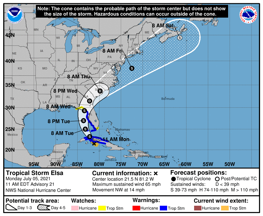
I don’t think the thunderstorm activity in today’s forecast is connected to Tropical Storm Elsa. As of the latest advisory, the storm is near the southern coast of Cuba and moving at 14 MPH (22 KM/H) toward the northwest.
Per the National Hurricane Center in Miami:

BULLETIN
Tropical Storm Elsa Advisory Number 21
NWS National Hurricane Center Miami FL AL052021
1100 AM EDT Mon Jul 05 2021
…ELSA NEAR THE SOUTH COAST OF CUBA…
…TROPICAL STORM WARNING EXTENDED NORTHWARD ALONG THE WEST COAST
OF FLORIDA…
SUMMARY OF 1100 AM EDT…1500 UTC…INFORMATION
———————————————–
LOCATION…21.5N 81.2W
ABOUT 20 MI…35 KM ESE OF CAYO LARGO CUBA
ABOUT 140 MI…225 KM SSE OF HAVANA CUBA
MAXIMUM SUSTAINED WINDS…65 MPH…100 KM/H
PRESENT MOVEMENT…NW OR 310 DEGREES AT 14 MPH…22 KM/H
MINIMUM CENTRAL PRESSURE…1006 MB…29.71 INCHES
WATCHES AND WARNINGS
——————–
CHANGES WITH THIS ADVISORY:
The Tropical Storm Warning along the west coast of Florida has been
extended northward to the Suwannee River, including Tampa Bay.
The Storm Surge Watch along the west coast of Florida has
been extended northward to the Ochlockonee River.
The Tropical Storm Watch along the coast of the Florida panhandle
has been extended westward to Indian Pass, Florida.
The government of Cuba has discontinued all watches and warnings
for the Cuban province of Camaguey.
The government of Cuba has changed the Hurricane Warning for the
Cuban provinces of Cienfuegos and Matanzas to a Tropical Storm
Warning, and has issued a Tropical Storm Warning for the Cuban
province of Artemisa.
SUMMARY OF WATCHES AND WARNINGS IN EFFECT:
A Tropical Storm Warning is in effect for…
* The Cuban provinces of Ciego de Avila, Sancti Spiritus,
Cienfuegos, Matanzas, Villa Clara, Mayabeque, Havana, and Artemisa
* The Florida Keys from Craig Key westward to the Dry Tortugas
* West coast of Florida from Flamingo northward to Suwannee River
A Storm Surge Watch is in effect for…
* West coast of Florida from Bonita Beach to the Ochlockonee River
A Tropical Storm Watch is in effect for…
* The Florida Keys from east of Craig Key to Ocean Reef
* Florida Bay
* North of the Suwannee River to Indian Pass, Florida
A Tropical Storm Warning means that tropical storm conditions are
expected somewhere within the warning area.
A Storm Surge Watch means there is a possibility of life-
threatening inundation, from rising water moving inland from the
coastline, in the indicated locations during the next 48 hours.
For a depiction of areas at risk, please see the National Weather
Service Storm Surge Watch/Warning Graphic, available at
hurricanes.gov.
A Tropical Storm Watch means that tropical storm conditions are
possible within the watch area.
Interests in coastal Georgia and the Carolinas should monitor the
progress of Elsa. Additional watches and warnings will likely be
required later today.
For storm information specific to your area in the United
States, including possible inland watches and warnings, please
monitor products issued by your local National Weather Service
forecast office. For storm information specific to your area
outside of the United States, please monitor products issued by
your national meteorological service.
DISCUSSION AND OUTLOOK
At 1100 AM EDT (1500 UTC), the center of Tropical Storm Elsa was
located near latitude 21.5 North, longitude 81.2 West. Elsa is
moving toward the northwest near 14 mph (22 km/h) , and this
general motion is expected to continue today, followed by a turn
toward the north-northwest on Tuesday. On the forecast track, Elsa
is expected to move across central and western Cuba later today and
pass near the Florida Keys early Tuesday. Elsa is then forecast to
move near or over portions of the west coast of Florida on Tuesday
and Wednesday.
Maximum sustained winds are near 65 mph (100 km/h) with higher
gusts. Some weakening is expected while the center moves over land.
Slight restrengthening is forecast after Elsa moves over the
southeastern Gulf of Mexico.
Tropical-storm-force winds extend outward up to 70 miles (110 km)
from the center.
The minimum central pressure estimated from NOAA Hurricane Hunter
observations is 1006 mb (29.71 inches).
HAZARDS AFFECTING LAND
WIND: Tropical storm conditions are expected in portions of central
and western Cuba today. Tropical storm conditions are expected in
the warning area in the Florida Keys tonight and along the
Florida west coast beginning Tuesday. Tropical storm conditions are
possible in the upper Florida Keys by tonight. Tropical storm
conditions are possible in the Florida Big Bend area beginning
Tuesday night.
STORM SURGE: A storm surge will raise water levels above normal
tide levels by as much as the following amounts in areas of onshore
flow within the hurricane watch and warning areas…
If Tropical Storm Elsa holds together, it will probably skirt the west coast of Florida with the center remaining offshore over the Gulf of Mexico. It’s too early to tell if that is what will happen, of course, but even in a best-case scenario where Elsa remains a weak tropical storm and does not come ashore anywhere near New Hometown, our weather is going to be bad between tomorrow morning and Wednesday evening. We could have lots of rain, flooded streets, and power outages. I hope that we don’t, of course, but as a Florida native who has lived in the state for 52 of his 58 years, I have to prepare mentally for those eventualities.
Anyway….

I didn’t do anything festive yesterday for the Fourth of July. I’m still not feeling all that well, what with that summer cold and its symptoms. The rest of the household watched the fireworks from the front porch, and the Caregiver and her boyfriend watched TV out in the common room afterwards (I could hear the television from my room because of the 5.1 home theater system it is connected to), but they did not invite me to hang out with them, so I sat in my room and played Command Modern Air Naval Operations (a modern naval warfare simulation similar to Harpoon) and Cold Waters.
After that I watched a documentary about Gen. William Tecumseh Sherman on Amazon Prime Video, but although I liked the visuals, I disliked the narration. It sounded like it was done by a bright but not-too-talented college history major for a college oral presentation. I watched about half of the show before turning it off and going to sleep on my futon.

As for today? I don’t think I’ll be able to do much of anything. I don’t know when the thunderstorms will start moving in, but I do know that I can’t use my computer – unless I use my laptop on battery power alone – once the lightning strikes start. Ditto for my television set and Blu-ray player. I’ve had my fair share of bad experiences that involved electronics and lightning, and I don’t want to have any more. Not if I can help it, anyway.
So I think today will be a good day for reading, and I have a lot of books on my TBR pile, including:
- The Napoleonic Wars: A Global History, Alexander Mikaberidze
- The Battle of Britain: Five Months That Changed History; May-October 1940, James Holland
- The Complete Maus, Art Spiegelman


I’ll try to get some movie-watching done before the weather deteriorates, but I need to take a shower and change into clean clothes first. I can’t do either during a thunderstorm, so I best get going.
So, until next time, Dear Reader, stay safe, stay healthy, and I’ll catch you on the less stormy side of things.


Comments
4 responses to “Musings & Thoughts for Monday, July 5, 2021, or: Of Storms, Summer Ailments, & Dealing with Weather-Related Ennui”
Good luck with Elsa … unless she gets a transfusion over the Gulf, she might not do too much damage. (relatively speaking)
LikeLiked by 1 person
We’ll just have to wait and see.
Thanks for the good wishes!
LikeLiked by 1 person
Been dipping into the French Revolutionary Wars ever and anon. Had a Western Civ teacher back in the day who thought Napoleon was just this short of the second coming. Even back then I was a smart ass enough to cough and say something like, “Didn’t like the weather in Russia, though…”
But he almost completely overlooked the revolutionary wars, when France stabilized its republic. More to the revolution than a lot of chopping off of heads.
Oh, I’m blathering….
LikeLiked by 1 person
*fingers crossed Elsa blows out*
LikeLike