
Hello, there, Constant Reader. It’s mid-morning in my corner of Florida on this penultimate day of July 2020 (a month and year, even, that I would love to see in my rearview mirror, and soon).
Right now, the temperature outside the house is 76˚F (24˚C) under mostly sunny skies; with humidity at 95% and an east-southeasterly breeze blowing at 3 MPH, the feels-like temperature is also 76˚F (24˚C), but as the sun climbs higher in the sky, the forecast high is expected to hit 90˚F (32˚C). Today’s weather prediction calls for high levels of humidity and lots of sun; in other words, it’s going to be a hellishly hot and sticky day, with heat indexes well over the 100˚F (37.778˚C) mark.
As if that wasn’t enough, Florida is in the path of Tropical Storm Isaias, which is currently in the northern Caribbean Sea but is expected to affect the Sunshine State by Saturday. Per the National Hurricane Center’s latest advisory:

SUMMARY OF 800 AM AST...1200 UTC...INFORMATION
----------------------------------------------
LOCATION...17.6N 68.5W
ABOUT 125 MI...205 KM W OF PONCE PUERTO RICO
ABOUT 105 MI...175 KM ESE OF SANTO DOMINGO DOMINICAN REPUBLIC
MAXIMUM SUSTAINED WINDS...60 MPH...95 KM/H
PRESENT MOVEMENT...NW OR 305 DEGREES AT 20 MPH...31 KM/H
MINIMUM CENTRAL PRESSURE...1003 MB...29.62 INCHES
DISCUSSION AND OUTLOOK
----------------------
At 800 AM AST (1200 UTC), the center of Tropical Storm Isaias was
located near latitude 17.6 North, longitude 68.5 West. Isaias is
moving toward the northwest near 20 mph (31 km/h), and a
west-northwestward to northwestward motion with some decrease in
forward speed is expected over the next couple of days.  On the
forecast track, the center of Isaias will move over Hispaniola later
today and near the Southeastern Bahamas by tonight or early Friday.
Isaias is forecast to be near the Central Bahamas Friday night and
approach the Northwest Bahamas or southern Florida Friday night and
Saturday.

Maximum sustained winds are near 60 mph (95 km/h) with higher
gusts. Little change in strength is anticipated until landfall in
Dominican Republic later today, with re-strengthening forecast on
Friday and Saturday.

Tropical-storm-force winds extend outward up to 415 miles (665 km)
from the center. Tropical-storm-force winds are occuring along the
southern coast of Puerto Rico. A Weatherflow station in Yabucoa
Tanque de Agua reported sustained winds of 46 mph (74 km/h) with a
gust to 56 mph (91 km/h).  A Weatherflow station at Las Mareas
reported sustained winds of 43 mph (69 km/h) with a gust to 54 mph
(87 km/h).

The estimated minimum central pressure is 1003 mb (29.62 inches).

I’ve experienced some of the worst storms to affect the state, including Hurricane Andrew in 1992 (which blew my mother’s backyard aluminum tool shed to shreds and left us without electricity for over two weeks), Hurricane Irene in 1999, which indirectly killed eight Floridians, including a young boy who was electrocuted when he stepped into a puddle near a downed power line not far from my old townhouse in East Wind Lake Village, and Hurricanes Katrina and Wilma in 2005.[1]
Right now, it looks like my home town of Miami is more likely to be affected than where I am living now. From what I can discern by looking at the forecast track, the storm will brush the east coast of Florida close to the Miami-Ft. Lauderdale metro area and head up the peninsula.
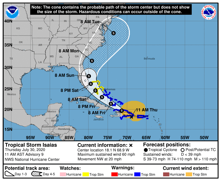
Because I had to go offline before I could post this earlier this morning, here’s an update on Isaias:
DISCUSSION AND OUTLOOK ———————- At 1100 AM AST (1500 UTC), the center of Tropical Storm Isaias was located near latitude 18.1 North, longitude 68.9 West. Isaias is moving toward the northwest near 20 mph (31 km/h), and a west- northwestward to northwestward motion with some decrease in forward speed is expected over the next couple of days. On the forecast track, the center of Isaias will move over Hispaniola today and move near the Southeastern Bahamas by tonight or early Friday. Isaias is forecast to be near the Central Bahamas Friday night and approach the Northwest Bahamas or southern Florida Friday night and Saturday. Maximum sustained winds are near 60 mph (95 km/h) with higher gusts. Some slight weakening is possible as Isaias moves over Hispaniola today. Re-strengthening is forecast on Friday and Friday night. Tropical-storm-force winds extend outward up to 310 miles (500 km) primarily to the north of the center. Tropical-storm-force winds are occuring along the southern coast of Puerto Rico. A Weatherflow station at Las Mareas, Puerto Rico, reported sustained winds of 45 mph (72 km/h) with a gust to 54 mph (87 km/h). A wind gust of 60 mph (96 km/h) was recently reported at Punta Cana on the eastern tip of the Dominican Republic. The estimated minimum central pressure is 1003 mb (29.62 inches).
National Hurricane Center 11 AM Advisory on TS Isaias
While I am not unduly alarmed about Isaias’ impact on my current place of residence, I am worried about my friends and family members who live in Miami. That worry extends to my estranged half-sister Vicky, who is still recovering from a second hip replacement operation and is probably not in the best of health at the moment.
I hope Isaias stays out to sea; tropical systems tend to be erratic in their movements, and I can remember several occasions when a storm changed course at the last minute and spared Miami. May that be the case with Isaias as well.
[1] Katrina, during its Category 1 phase, crossed South Florida directly over my neighborhood during the night of August 25/26, 2005. I remember going outside late at night – probably around 11:30 PM or so – and looking up at a huge area of clear night sky and the stars twinkling. The lights never went out, or at least, I don’t remember them going out. But there was a lot of flooding in my neighborhood; NW 97th Avenue, which is adjacent to a north-south canal, looked like a raging river when I went outside to survey the impact of the storm. It was a mess, let me tell you.
Wilma was far more destructive. Whilst Andrew “only” destroyed my mom’s aluminum tool shed (inadvertently doing us a favor; the Board of Directors was cracking down on HOA violations of approved alterations to individual units in the condo, and tool sheds were suddenly on the Board’s verboten list after years of not bothering to remind owners of the prohibition) and Katrina only caused a brief power outage, Wilma tore off a third of the townhouse’s roof and caused flooding in the upstairs bedrooms. It also destroyed or damaged many of my 1980s-era Kenner Star Wars collectibles.

Comments
2 responses to “Musings & Thoughts, July 30, 2020: Keeping a Weather Eye on Isaias”
I remember Hurricane Andrew. I remember I was living in Maryland at the time and some of my relatives called to say that they had lost their homes. I watched the news reports on television and I could not believe the damage.
LikeLiked by 1 person
Our neighborhood got off RELATIVELY lucky; there were quite a few units that suffered extensive damage when trees fell on them or on parked cars, but we didn’t have the apocalyptic destruction that Andrew wreaked further south. We had power throughout that horrible night and early morning; we lost it when Florida Power & Light cut it because there were too many downed trees and fallen poles outside our perimeter. Further south, especially in a community called Country Walk, the damage was more catastrophic.
We also lost our biggest military asset at the time, Homestead Air Force Base. Andrew did so much damage there that the Bush Administration had to close it as a full-on Air Force Base. It’s now a mixed civilian airport/Air Reserve Base. But yes. Andrew was a nightmare.
LikeLiked by 1 person