Well, it’s late afternoon here in my quiet corner of Florida; it’s still sunny outside, and even though the temperature is lower than it was when I chimed in this morning, it’s still hot and muggy outside. Presently, the temperature is 83˚F (28˚C), although with humidity at 74% and northeasterly winds blowing at 14 MPH, it feels like it’s 89˚F (31˚C) out in the open and away from shady areas.
It probably isn’t so nice in my former neighborhood in the Miami area, though. Although it seems that Isaias is currently a tropical storm, it still is headed for the Atlantic coast of Florida and is expected to be offshore tomorrow.
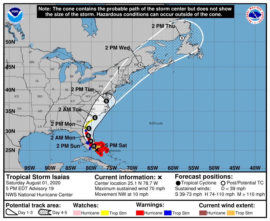
Per the National Hurricane Center – which is located not too far from where I used to live – here is the latest update on Isaias:
BULLETIN
Tropical Storm Isaias Advisory Number 19
NWS National Hurricane Center Miami FL AL092020
500 PM EDT Sat Aug 01 2020
…ISAIAS WEAKENS TO A TROPICAL STORM…
…EXPECTED TO RE-STRENGTHEN TO A HURRICANE OVERNIGHT WHILE IT
APPROACHES THE SOUTHEAST COAST OF FLORIDA…
SUMMARY OF 500 PM EDT…2100 UTC…INFORMATION
———————————————-
LOCATION…25.1N 78.7W
ABOUT 115 MI…185 KM SE OF FORT LAUDERDALE FLORIDA
ABOUT 95 MI…155 KM S OF FREEPORT GRAND BAHAMA ISLAND
MAXIMUM SUSTAINED WINDS…70 MPH…110 KM/H
PRESENT MOVEMENT…NW OR 310 DEGREES AT 10 MPH…17 KM/H
MINIMUM CENTRAL PRESSURE…993 MB…29.33 INCHES

The latest advisory also goes on to say:
DISCUSSION AND OUTLOOK
———————-
At 500 PM EDT (2100 UTC), the center of Tropical Storm Isaias was
located by an Air Force Reserve reconnaissance aircraft near
latitude 25.1 North, longitude 78.7 West. Isaias is moving toward
the northwest near 10 mph (17 km/h). A general northwestward
motion with some decrease in forward speed is expected for the next
day or so, followed by a north-northwestward motion by late Sunday
and a turn toward the north and north- northeast on Monday and
Tuesday with an increase in forward speed. On the forecast track,
the center of Isaias will approach the southeast coast of Florida
tonight and move near or along the east coast of Florida Sunday and
Sunday night. On Monday and Tuesday, the center of Isaias will move
quickly from offshore of the coast of Georgia into the southern
mid-Atlantic states.
Maximum sustained winds have decreased to near 70 mph (110 km/h)
with higher gusts. Some restrengthening is forecast, and Isaias
is expected to regain hurricane strength tonight. Slow weakening is
expected to begin Sunday night and continue through Monday.
Tropical-storm-force winds extend outward up to 105 miles (165 km)
from the center. During hew past couple of hours, a Weatherflow
observing site at the Dania Pier in Broward County, Florida,
reported a wind gust to 59 mph (94 km/h) in an outer rainband. More
recently, a wind gust to 41 mph (67 km/h) was reported by a
Weatherflow site in Juno Beach, Florida.
The estimated minimum central pressure based on reconnaissance
aircraft data is 993 mb (29.33 inches)
A general northwestward
motion with some decrease in forward speed is expected for the next day or so, followed by a north-northwestward motion by late Sunday and a turn toward the north and north- northeast on Monday and Tuesday with an increase in forward speed. On the forecast track, the center of Isaias will approach the southeast coast of Florida tonight and move near or along the east coast of Florida Sunday and
Sunday night.
National Hurricane Center, 5 PM Advisory on Tropical Storm Isaias, August 1, 2020
In any event, I think my area will be spared the worst effects, although I can’t dismiss the possibility that we will have periods of rough weather – rain squalls, wind gusts over 50 MPH, and localized power failures due to downed power lines and whatnot. The East Coast, from Miami northward, will bear the brunt of Isaias’ (hopefully) offshore presence.
I don’t have an exaggerated fear of cyclonic storms; I’ve been through quite a few hurricanes, tropical storms, and even unorganized “no-name storms” that hit Florida as parts of tropical waves or undeveloped depressions. I do respect their power, though, and when a hurricane or tropical storm is this close to my home state and my former city of residence, I still feel concern for the friends and even relatives I left behind.

And, let’s be honest: sometimes I do get homesick and regret not only the estrangement – unavoidable as it was – between my older half sister and me, but also the loss of my house. I know that this is purely a visceral rather than a logical way to see things, but I miss being a homeowner and having some control over my destiny.
Intellectually, I know that unless my half-sister and I had been able to reconcile our many differences and pooled our resources and talents to repair and renovate the townhouse I left in Miami, I would still have lost it. There’s no way, based on my financial realities, that I could have afforded to live alone “at home.” I don’t think I would have liked renting a room to a total stranger, and even under the best of circumstances, there’s no way that Vicky and I could have lived harmoniously under the same roof.
So, homesickness aside, I’m lucky to be where I am today.

You must be logged in to post a comment.