Late Morning/Midday, Tuesday, August 29, 2023, Lithia, Florida
“That’s something every islander knows–there’s always going to be another hurricane. Another storm. Everything buried will surface again, and everything you thought would last forever will come down eventually. But you rebuild. You dredge. You keep moving, keep adding new. That’s how we go on living.” ― Roseanna M. White, Yesterday’s Tides

Hi, everyone.

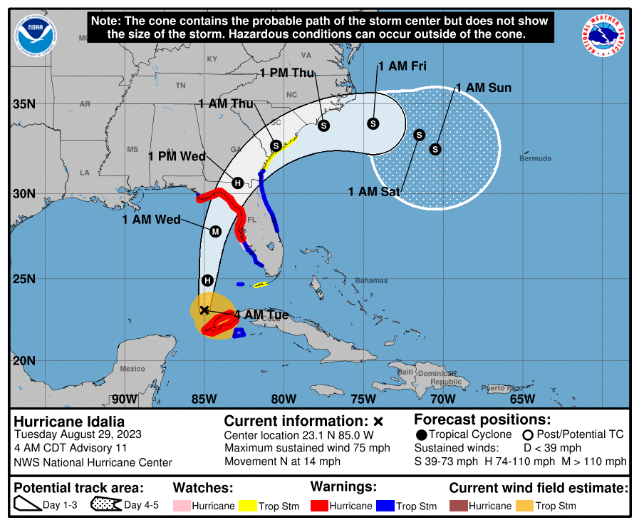
It’s late morning here in the Tampa Bay area on this last Tuesday of August, the final Tuesday of Summer 2023. And this being Florida and the subtropical zone of North America, it’s a torrid, sullen, and tense day. The temperature outside is 88°F/31°C under mostly cloudy conditions. With humidity at 64% and an east-southeasterly breeze blowing at 9 MPH/14 KMH, the heat index is already 100°F/38°C. The forecast for today calls for partly sunny skies and a high of 92°F/33°C, although – thanks to the approach of Hurricane Idalia, we can expect heavy rain tonight.
As for Idalia, here is the latest advisory from the National Hurricane Center in Miami:
HURRICANE IDALIA FORECAST/ADVISORY NUMBER 12
NWS NATIONAL HURRICANE CENTER MIAMI FL AL102023
1500 UTC TUE AUG 29 2023
NOTICE… LAND-BASED TROPICAL CYCLONE WATCHES AND WARNINGS ARE NO
LONGER INCLUDED IN THE TROPICAL CYCLONE FORECAST/ADVISORY…(TCM).
CURRENT LAND-BASED COASTAL WATCHES AND WARNINGS CAN BE FOUND IN THE
MOST RECENTLY ISSUED TROPICAL CYCLONE PUBLIC ADVISORY…(TCP).
HURRICANE CENTER LOCATED NEAR 24.6N 84.8W AT 29/1500Z
POSITION ACCURATE WITHIN 15 NM
PRESENT MOVEMENT TOWARD THE NORTH OR 5 DEGREES AT 12 KT
ESTIMATED MINIMUM CENTRAL PRESSURE 976 MB
MAX SUSTAINED WINDS 75 KT WITH GUSTS TO 90 KT.

64 KT……. 15NE 15SE 0SW 10NW.
50 KT……. 30NE 40SE 20SW 20NW.
34 KT…….100NE 140SE 50SW 60NW.
12 FT SEAS.. 90NE 150SE 60SW 75NW.
WINDS AND SEAS VARY GREATLY IN EACH QUADRANT. RADII IN NAUTICAL
MILES ARE THE LARGEST RADII EXPECTED ANYWHERE IN THAT QUADRANT.
REPEAT…CENTER LOCATED NEAR 24.6N 84.8W AT 29/1500Z
AT 29/1200Z CENTER WAS LOCATED NEAR 23.8N 84.8W
FORECAST VALID 30/0000Z 26.5N 84.6W
MAX WIND 90 KT…GUSTS 110 KT.
64 KT… 20NE 20SE 10SW 10NW.
50 KT… 40NE 50SE 30SW 20NW.
34 KT…120NE 150SE 70SW 80NW.
FORECAST VALID 30/1200Z 29.3N 83.7W
MAX WIND 110 KT…GUSTS 135 KT.
64 KT… 25NE 25SE 10SW 10NW.
50 KT… 40NE 40SE 20SW 20NW.
34 KT… 90NE 150SE 70SW 70NW.
FORECAST VALID 31/0000Z 31.8N 81.7W…INLAND
MAX WIND 55 KT…GUSTS 65 KT.
50 KT… 40NE 40SE 20SW 20NW.
34 KT… 70NE 140SE 50SW 40NW.
FORECAST VALID 31/1200Z 33.5N 78.8W…OVER WATER
MAX WIND 45 KT…GUSTS 55 KT.
34 KT… 70NE 120SE 70SW 40NW.
FORECAST VALID 01/0000Z 34.1N 75.6W
MAX WIND 45 KT…GUSTS 55 KT.
34 KT…120NE 100SE 70SW 60NW.
FORECAST VALID 01/1200Z 33.8N 73.0W
MAX WIND 45 KT…GUSTS 55 KT.
34 KT…140NE 60SE 90SW 120NW.
EXTENDED OUTLOOK. NOTE…ERRORS FOR TRACK HAVE AVERAGED NEAR 125 NM
ON DAY 4 AND 175 NM ON DAY 5…AND FOR INTENSITY NEAR 15 KT EACH DAY
OUTLOOK VALID 02/1200Z 32.5N 70.2W
MAX WIND 45 KT…GUSTS 55 KT.
OUTLOOK VALID 03/1200Z 32.0N 68.8W
MAX WIND 45 KT…GUSTS 55 KT.
REQUEST FOR 3 HOURLY SHIP REPORTS WITHIN 300 MILES OF 24.6N 84.8W
INTERMEDIATE PUBLIC ADVISORY…WTNT35 KNHC/MIATCPAT5…AT 29/1800Z
NEXT ADVISORY AT 29/2100Z
$$
FORECASTER BERG
Hurricane Idalia is going to make landfall somewhere on the Gulf Coast of Florida tomorrow. Based on the latest information from the National Hurricane Center, the most likely location for a direct hit is the Apalachicola Bay/Big Bend area that marks the beginning of the Florida Panhandle, especially if the storm keeps heading north and doesn’t begin taking its Coriolis Effect turn to the right this afternoon or evening.
If that happens, Hillsborough County will only have to deal with the outer bands of Idalia rather than suffer the more severe effects of a full-on strike by a Category Three or Four storm. Trust me on this…outer bands are nasty and can do serious damage, mainly from flash floods caused by heavy rain and wind damage from tropical storm-strength winds and tornadoes spun off by the thunderstorm activity in those outer bands. But…a full-on visit by Idalia will do more damage than a glancing blow.
On Writing & Storytelling: Action This Day

I started writing the third scene in Reunion: Coda’s Chapter 11 yesterday afternoon, but – predictably – the distracting effects of “hurricane anxiety” prevented me from writing more than 97 new words.
That’s better than nothing, I suppose, but I hope that I will be able to be more productive than that after my rest period. I want to, of course, and I’ll do my best to write as much – and as best – as humanly possible.

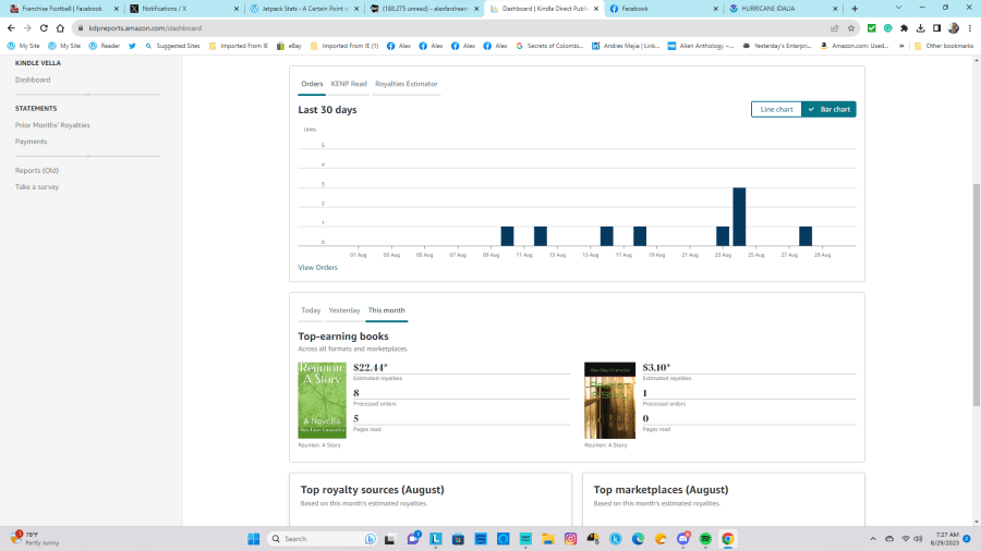
As for the existing book in the Reunion Duology, August 2023 saw a modest bump in sales, especially during the last week of the month.
Per Kindle Direct Publishing, there were processed orders – eight in the United States, and one in Spain, all from Amazon – of the paperback. Over on Kindle Unlimited, someone read five pages of Reunion. In all, unless someone buys one more copy between now and Thursday, I stand to earn $25.24 in royalties. Not enough to earn an independent living, but better than no royalties at all.


Anyway, unless the weather takes a turn for the worse today, I will stick to my regular schedule and work on Reunion: Coda.
That’s “all the news that fit to print,” my friends, so I’ll close for now. Until next time, stay safe, stay healthy, and I’ll catch you on the sunny side of things.

Comments
10 responses to “Musings & Thoughts for Tuesday, August 29, 2023, or: As Hurricane Idalia Approaches, the Writing Goes On (Trouble in the Tropics Edition)”
Stay safe.
LikeLiked by 1 person
I’ll do my best!
LikeLiked by 1 person
Stay high and dry. No fun.
LikeLiked by 1 person
Luckily, we aren’t going to withstand the worst of Idalia. We’ll get heavy rain…and hopefully no power outages in our area.
LikeLiked by 1 person
I hope that’s still true.
LikeLiked by 1 person
‘Tis. I just woke up. Idalia is hitting “the armpit of Florida” now as a Category 3. It was a Category 4 earlier (while I slept), but it was too far out to sea to seriously affect the Tampa Bay area. As I write this, there are still some outer bands overhead, but they should be gone by late morning/noon.
LikeLiked by 1 person
I saw the news about hurricane Idalia and that the predicted path was pretty close to where you live. The news I read was category 3 north of Tampa. I hope you will be safe.
LikeLiked by 1 person
I’m not unduly concerned. Idalia is heading north and won’t make landfall in the Tampa Bay area. We’re feeling the outer bands, yes, but the hurricane force winds will stay out at sea. There is the possibility of power outages, of course, but I think we’ll be okay where I live.
LikeLiked by 1 person
That sounds good. A power outage could still be a problem though. Maybe Trump could take out his Sharpie and move the hurricane to Cuba. That way you will be safe for certain.
LikeLiked by 1 person
No Trumpian intervention was necessary. We’re still getting some of the outer bands, but they’ll be out of the area by the afternoon.
LikeLike