
Hi there, Dear Reader. As I write this, it’s mid-afternoon here in my corner of Florida, and it’s a dreary, stormy one at that, too. Currently, the temperature outside is 88 degrees Fahrenheit (31 degrees Celsius) under rainy conditions; with humidity at 74% and a southwesterly breeze blowing at 6 MPH, the feels-like temperature is 102 degrees Fahrenheit (38 degrees Celsius) even with rain and thunderstorms creating a dark and cheerless shroud overhead.
Today we went to the bank to cash a couple of checks that I received over the past month. I was ready to go as early as 11 AM, but my partner decided to wait until after 2 PM to go to the nearest branch of the bank where we both have accounts. That wasn’t the best of decisions; we got stuck in bumper-to-bumper traffic, and a simple errand that normally takes us 30 to 45 minutes – tops – took over an hour.
We accomplished our mission and got home during a lull in the torrential rain, which has resumed, accompanied by occasional lightning strikes and loud “BOOMS” of angry-sounding thunder. Nothing too close, at least for the moment, but as soon as I post this I’ll log off; I’ve lost several electronic devices to lightning strikes over the years, so I don’t want this PC to join the Fried Electronics bunch.
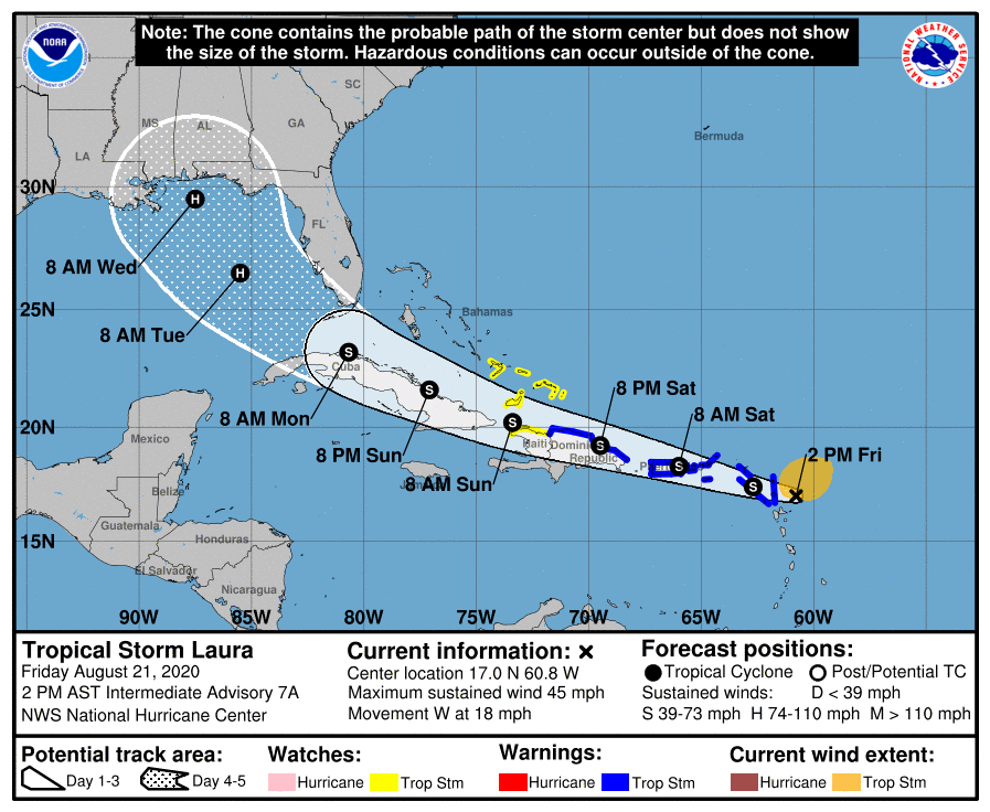
At least I know that the inclement weather is just a part of the typical Florida summer weather pattern and not related to Tropical Storm Laura, which is one of two tropical systems that threaten to hit the southern U.S. sometime next week. Laura formed, I believe, yesterday and is still over 1,000 miles away from my present hometown. It’s predicted to affect the Leeward Islands and Puerto Rico on Saturday, then pass through the Straits of Florida (between Cuba and South Florida) on Monday morning before going to the Gulf of Mexico.
As of right now, I’m not too worried about Tropical Storm Laura; based on its current location, its track is too far to the south to predict that it’ll hit either Miami (where I used to live) and my current location, and since it is going to pass through the mountainous Greater Antilles (Puerto Rico, Hispaniola, and Cuba), it might not become an Andrew/Katrina-like Category Five monster.
Per the Miami Herald’s article about Laura:
Tropical Storm Laura’s latest track has shifted south, taking most of Florida out of the forecast cone except the Florida Keys, which declared a local state of emergency.
Laura is set to cross directly over the northern Leeward Islands late Friday into Saturday and Puerto Rico sometime Saturday.
As a Floridian, I’ll keep a weather eye on Laura, but I think that, barring a drastic turn in the storm’s path, my corner of the Sunshine State probably won’t get a direct hit from the hurricane.
Source: https://www.miamiherald.com/news/weather/hurricane/article245107930.html?

Comments
2 responses to “Thoughts & Musings on a Rainy Friday, August 21, 2020”
I’ve already got people panicking about Destin. It’s a wait and see situation right now. Shouldn’t be a major hurricane, but enough to make life miserable at least.
LikeLiked by 1 person
I hope it doesn’t head to the Panhandle…we’ll have to see, as the Polaroid commercials used to say, what develops.
LikeLiked by 2 people