Hello, there. I would say “Good morning,” since it is just past 9 AM in my little corner of Florida, but I know that many of you live in other parts of the world where it is already afternoon. Right now it is a dark morning, as the sky is mostly cloudy (over 80% cloud cover), which means that it is going to be a soggy, rainy day like it was for most of yesterday. The current temperature is 77 degrees Fahrenheit (25 degrees Celsius) in both “real” and “feels like” terms, and the forecast calls for rain in the evening hours.
In case you’re wondering: No, this has nothing to do with Tropical Storm Laura; that cyclone is still way out in the Caribbean Sea, where its winds, rain, and rough sea conditions are expected to spoil the weekend for the Leeward Islands, the Virgin Islands, and Puerto Rico. That’s over 1,200 miles away from where I sit, and while tropical storms are large weather events, they are not that huge.
In any case, barring a freakish change in the steering currents and other conditions that determine where Laura heads, I believe that Floridians, even those in the Lower Keys, can relax about this storm. The latest forecast track has the storm moving westward, yes, but further enough to the south that no part of Florida will be in Laura’s path.
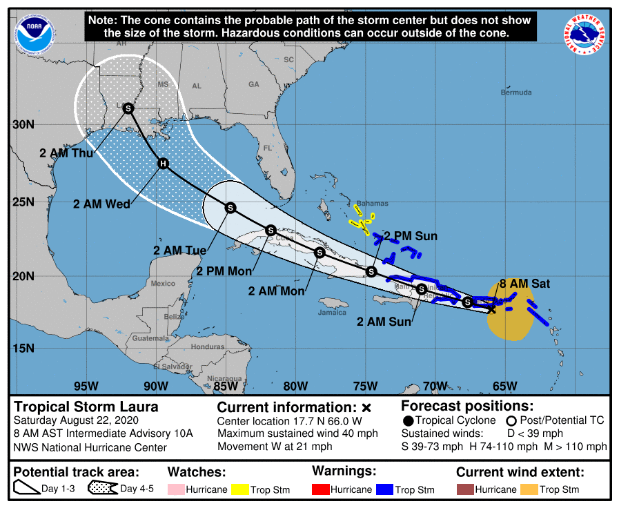
Per the 8 AM advisory from the National Hurricane Center in Miami:
DISCUSSION AND OUTLOOK
----------------------
At 800 AM AST (1200 UTC), the center of Tropical Storm Laura was
located near latitude 17.7 North, longitude 66.0 West. Laura is
moving toward the west near 21 mph (33 km/h), and a generally
west-northwestward motion is expected over the next few days.  On
the forecast track, the center of Laura will move near Puerto Rico
this morning, near or over Hispaniola this afternoon and tonight,
and near or over eastern Cuba Sunday and Sunday night.

Maximum sustained winds are near 40 mph (65 km/h) with higher gusts.
Slow strengthening is expected during the next few days.

Tropical-storm-force winds extend outward up to 205 miles (335 km)
mainly to the north of the center.

The estimated minimum central pressure based on surface
observations is 1006 mb (29.71 inches).
While it is always a good idea to keep a weather eye on any tropical system near the Sunshine State, I think our area has dodged a bullet with Tropical Storm Laura. I mean, sure, a butterfly in Beijing could beat its wings a certain way and create a ripple effect to make Laura make a screeching turn to the right and head here, but the conditions aren’t right for that.
I’ll probably be back later with a review, gaming report, or “social commentary” post. It’s early in the day for me, and I don’t really have anything else on my daily planner for this Saturday in August. So, see you around, Dear Reader!

Comments
2 responses to “Thoughts & Musings on a Saturday Morning, August 22, 2020”
It’s going to be interesting to see what happens when the two systems get close to each other. I would be pretty scared right now in northeastern Texas and Louisiana.
LikeLiked by 2 people
I would be, too!
LikeLike