
Hello, Dear Reader. It is early afternoon here in New Hometown, Florida, on Wednesday, November 11, 2020. It is a dark, blustery day here; the current temperature is 78˚F (25˚C) under rainy conditions. With humidity at 96% and the wind blowing from the east-southeast at 14 MPH (22 KM/H), the feels-like temperature is 78˚F (25˚C). There is a flood watch for our area, as there is a river close to my neighborhood, as well as a slew of other advisories, including a tropical storm warning effective today and tomorrow.
Right now, the rain is not too bad – it is light, not torrential, and we haven’t had any lightning strikes from the squalls and thunderstorms associated with Hurricane Eta. Still, it is keeping me stuck indoors; I am not foolish enough to go outside on a rainy day unless I want to catch a cold or the flu. And because I can’t go out in this horrible, damp, and cold weather, I feel like the walls of my room – which is the smallest of the five bedrooms here – closing in on me.

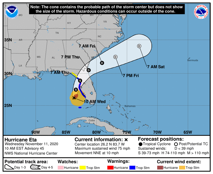
Per the National Hurricane Center in Miami:
000
WTNT34 KNHC 111449
TCPAT4
BULLETIN
Hurricane Eta Advisory Number 45
NWS National Hurricane Center Miami FL AL292020
1000 AM EST Wed Nov 11 2020
…HEAVY SQUALLS WITH TROPICAL-STORM-FORCE WINDS SPREADING ONSHORE
THE SOUTHWESTERN COAST OF FLORIDA…
…STORM SURGE WARNING ISSUED FOR A PORTION OF THE FLORIDA WEST
COAST…
SUMMARY OF 1000 AM EST…1500 UTC…INFORMATION
———————————————–
LOCATION…26.2N 83.7W
ABOUT 115 MI…180 KM WSW OF PORT CHARLOTTE FLORIDA
ABOUT 145 MI…235 KM SSW OF TAMPA FLORIDA
MAXIMUM SUSTAINED WINDS…75 MPH…120 KM/H
PRESENT MOVEMENT…NNE OR 15 DEGREES AT 10 MPH…17 KM/H
MINIMUM CENTRAL PRESSURE…983 MB…29.03 INCHES
WATCHES AND WARNINGS
——————–
CHANGES WITH THIS ADVISORY:
A Storm Surge Warning has been issued for the Florida west coast
from Suwannee River to Bonita Beach, including Tampa Bay and
Charlotte Harbor.
The government of Cuba has discontinued the Tropical Storm Watch
for Cuba.
SUMMARY OF WATCHES AND WARNINGS IN EFFECT:
A Storm Surge Warning is in effect for…
* Bonita Beach to Suwanee River Florida, including Tampa Bay
and Charlotte Harbor
A Hurricane Watch is in effect for…
* Anna Maria Island to Yankeetown
A Tropical Storm Warning is in effect for…
* Dry Tortugas
* Bonita Beach to Suwannee River Florida
A Storm Surge Watch is in effect for…
* Steinhatchee River to Suwannee River Florida
A Tropical Storm Watch is in effect for…
* North of the Suwannee River to Aucilla River Florida
A Hurricane Watch means that hurricane conditions are possible
within the watch area, in this case within 24 hours.
A Tropical Storm Warning means that tropical storm conditions are
expected somewhere within the warning area, in this case within 24
hours.
A Storm Surge Warning means there is a danger of life-threatening
inundation, from rising water moving inland from the coastline, in
this case within 24 hours in the indicated locations. For a
depiction of areas at risk, please see the National Weather Service
Storm Surge Watch/Warning Graphic, available at hurricanes.gov.
This is a life-threatening situation. Persons located within these
areas should take all necessary actions to protect life and property
from rising water and the potential for other dangerous conditions.
Promptly follow evacuation and other instructions from local
officials.
A Storm Surge Watch means there is a possibility of life-
threatening inundation, from rising water moving inland from the
coastline, in this case within 24 hours. For a depiction of areas
at risk, please see the National Weather Service Storm Surge
Watch/Warning Graphic, available at hurricanes.gov.
A Tropical Storm Watch means that tropical storm conditions are
possible within the watch area.
Interests elsewhere along the Gulf Coast of Florida should monitor
the progress of Eta. Additional warnings may be required along
portions of the Florida Peninsula today.
For storm information specific to your area, including possible
inland watches and warnings, please monitor products issued by your
local National Weather Service forecast office.
It doesn’t look like it’s going to be a good day – weatherwise, anyway – on this Veterans’ Day 2020.
The only good news about this storm is (a) that it is not a major (Category 2 or higher) hurricane; (b) the forecast track indicates that will make landfall tomorrow well to the north of where I live; and (c) Eta will be downgraded to a tropical storm by the time it hits land.
Other than that…ugh.
I will probably work on The Tonic of Their Victory later this afternoon. I will read a bit more from the books I am using as historical references to understand the July battles on Normandy a bit better. I don’t know how much time I’ll spend reading or if I will actually do any writing – the grayness of the day and the forced stay indoors are making me fidgety and irritable.

On the good news front – UPS is delivering my new UHD 4K TV today. It was scheduled to be delivered yesterday, but the approach of Eta probably played havoc with the supply chain (although I can’t see how, because the TV set was shipped from Atlanta and not the Eta-affected city of Miami). Per UPS, my UHD TV was in Lakeland, FL this morning and is listed as Out for Delivery. Supposedly, it will be here before 9 PM, but…we’ll see.
That’s all the news I have for you right now, Dear Reader. I’ll probably chime in later with an update. Till then, though, stay safe, stay healthy, and be kind to others.

You must be logged in to post a comment.