
Hi, there, Dear Reader. Well, it’s early afternoon – just a bit past 2 PM Eastern – on Thursday, November 12, 2020. Currently, the temperature is 79˚F (26˚C) under mostly cloudy skies. With humidity at 88% and the wind blowing from the west-southwest at 15 MPH (24 KM/H), the feels-like temperature is 79˚F (26˚C). The rest of the afternoon should be rainy, and there is a flood watch for our immediate area. Tonight, the skies will clear as what remains of Eta is now offshore near the Florida-Georgia border and its outer bands will be farther and farther away from New Hometown, Florida.
Here is the latest on Eta from the National Hurricane Center in Miami:
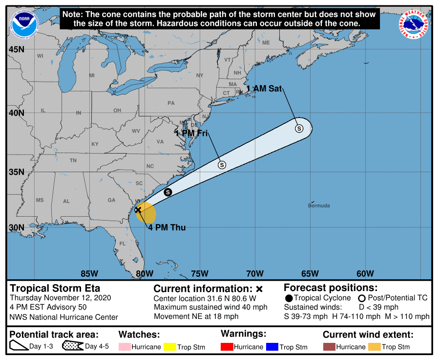
BULLETIN
Tropical Storm Eta Intermediate Advisory Number 49A
NWS National Hurricane Center Miami FL AL292020
100 PM EST Thu Nov 12 2020
…ETA MOVING OFFSHORE OVER THE ATLANTIC WATERS NEAR THE
FLORIDA/GEORGIA BORDER…
SUMMARY OF 100 PM EST…1800 UTC…INFORMATION
———————————————-
LOCATION…30.8N 81.4W
ABOUT 40 MI…65 KM NNE OF JACKSONVILLE FLORIDA
MAXIMUM SUSTAINED WINDS…40 MPH…65 KM/H
PRESENT MOVEMENT…NNE OR 30 DEGREES AT 15 MPH…24 KM/H
MINIMUM CENTRAL PRESSURE…1004 MB…29.65 INCHES
WATCHES AND WARNINGS
——————–
CHANGES WITH THIS ADVISORY:
All Tropical Storm Warnings have been discontinued.
SUMMARY OF WATCHES AND WARNINGS IN EFFECT:
There are no coastal watches or warnings in effect.
For storm information specific to your area, including possible
inland watches and warnings, please monitor products issued by your
local National Weather Service forecast office.
DISCUSSION AND OUTLOOK
———————-
At 100 PM EST (1800 UTC), the center of Tropical Storm Eta was
located near latitude 30.8 North, longitude 81.4 West. Eta is moving
toward the north-northeast near 15 mph (24 km/h). A faster
north-northeastward to northeastward motion is expected over the
next couple of days. On the forecast track, Eta is expected to
accelerate over the western Atlantic and move parallel to, but
offshore of the Carolinas tonight and early Friday before heading
well east of the Mid-Atlantic coast by late Friday.
Maximum sustained winds are near 40 mph (65 km/h) with higher
gusts. Little change in strength is forecast through early Friday.
Eta could re-intensify as a non-tropical cyclone late Friday or
Friday night before becoming absorbed by a larger non-tropical
cyclone on Saturday.
Tropical-storm-force winds extend outward up to 115 miles (185 km)
primarily over water to the east of the center.
The estimated minimum central pressure is 1004 mb (29.65 inches).
As for New Hometown, the NHC has this to say:
HAZARDS AFFECTING LAND
———————-
Key messages for Eta can be found in the Tropical Cyclone Discussion
under AWIPS header MIATCDAT4, WMO header WTNT44 KNHC, and on the
web at www.hurricanes.gov/text/MIATCDAT4.shtml.
RAINFALL: Eta will produce an additional 1 to 3 inches of rain
across portions of the Florida Peninsula through today, with
isolated maximum storm total accumulations of 20 to 25 inches in
South Florida.
Localized flash and urban flooding will be possible across the
Florida Peninsula today, especially across previously inundated
areas. Minor river flooding is expected across portions of West
Florida lasting into the weekend.
Happily, Eta didn’t come ashore near my neighborhood; we had rain throughout the night, yeah, but we didn’t lose electricity or experience any thunderstorms, tornados, or dangerously high winds. I did see in the news that a few thousand residents in the five or six counties that make up our region of Florida lost power, and quite a few trees were blown down in some places. But there wasn’t an Andrew- or Katrina-like disaster here.

Meanwhile…..
I’m a bit tired because I woke up – once again – before 5 AM; the Caregiver’s 25-year old son is a smoker and a gamer, and because his room is adjacent to mine I can hear when (a) he gets overly exuberant while playing Fortnite or (b) has a coughing fit. This morning I was awakened by a seemingly endless bout of coughs and hacks that sounded as if the young man would expel lung tissue and Lord knows what else. After a while – don’t ask me how long – the coughs stopped and all was quiet again, but I couldn’t go back to sleep.
So…now I feel like a zombie straight out of The Walking Dead. I ate breakfast, had coffee, and I even heated a Stouffer’s French Bread Pizza for lunch – downing that last with a can of Coca-Cola – and I still feel like my brain is wrapped in fluffy balls of cotton. All I want to do is listen to some tunes and not do anything that feels like work.
(Even this blog post has been a laborious Sisyphean endeavor for me. I started writing at 2:07 PM; it is now almost 4:30 PM!)
Since it doesn’t look like my current state of lethargy is going to dissipate any time soon, I’ll just go ahead and wrap this up. Maybe I’ll get a good night’s rest and wake up tomorrow with vim and vigor!

Comments
8 responses to “Musings & Thoughts for Thursday, November 12, 2020, or: Eta’s Gone, But I’m a Zombie…or Feel Like One, Anyway”
I hate when that happens. I know what you mean. I routinely am up entirely too early. Some nights it’s as early as 2:30 and I can’t get back to sleep.
LikeLiked by 2 people
Yikes…0230 is definitely way, way, way too early.
LikeLiked by 2 people
Oh, man! I’m routinely up between 4:30 and 5 just ‘cuz. I like the quiet of the early morning. That’s okay. Waking up and 2:30 would have me in the sleeping walking twelve hours later.
LikeLiked by 2 people
I used to wake up around 2, 2:30, and be awake for 2 hours, then sleep till 8-ish. Now I have my granddaughter from when her Mom leaves around 6:30 till I drive her to school at 8:30. So if I’m awake anytime after 4 there’s no point in going back to sleep.
LikeLiked by 1 person
I just hope I can get a decent night’s sleep tonight…..
LikeLike
Wow, for a second there I thought that image was San Franciso!
LikeLike
It might be. It is, after all, a Pexels photo..I just like the clouds.
LikeLiked by 1 person
🙂
LikeLike